|
|
|||||||||||||||||
| Point ID: 484 | Downloads | Plots | Site Data | Code: 05DF002 |
|
|
|||||||||||||||||
| Download | |
|---|---|
| Site Descriptor Information | Site Time Series Data |
| Link to all available data | |
| View: | Time Series | All |
| Units: | m3/s |
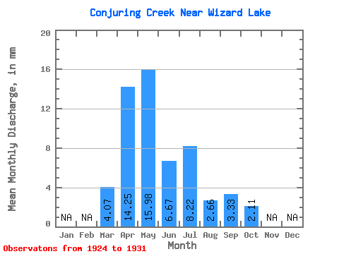
| Statistic | Jan | Feb | Mar | Apr | May | Jun | Jul | Aug | Sep | Oct | Nov | Dec | Annual |
|---|---|---|---|---|---|---|---|---|---|---|---|---|---|
| Mean | 4.11 | 14.24 | 15.95 | 6.70 | 8.24 | 2.63 | 3.33 | 2.13 | |||||
| Standard Deviation | 5.81 | 16.02 | 28.84 | 4.71 | 13.98 | 3.34 | 5.36 | 2.60 | |||||
| Min | 0.00 | 0.00 | 0.00 | 1.67 | 0.23 | 0.00 | 0.30 | 0.63 | |||||
| Max | 8.22 | 35.85 | 74.55 | 13.34 | 33.12 | 8.38 | 11.37 | 6.03 | |||||
| Coefficient of Variation | 1.41 | 1.12 | 1.81 | 0.70 | 1.70 | 1.27 | 1.61 | 1.22 |
 Return to R-Arctic Net Home Page