|
|
|||||||||||||||||
| Point ID: 48 | Downloads | Plots | Site Data | Code: 05AB030 |
|
|
|||||||||||||||||
| Download | |
|---|---|
| Site Descriptor Information | Site Time Series Data |
| Link to all available data | |
| View: | Time Series | All |
| Units: | m3/s |
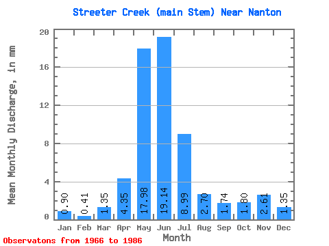
| Statistic | Jan | Feb | Mar | Apr | May | Jun | Jul | Aug | Sep | Oct | Nov | Dec | Annual |
|---|---|---|---|---|---|---|---|---|---|---|---|---|---|
| Mean | 0.75 | 0.48 | 1.40 | 4.28 | 18.04 | 18.92 | 8.90 | 2.88 | 1.57 | 1.71 | 2.46 | 1.35 | 98.67 |
| Standard Deviation | 1.09 | 0.66 | 1.67 | 7.03 | 17.30 | 19.34 | 13.33 | 2.53 | 1.31 | 2.65 | 3.30 | 1.86 | 63.97 |
| Min | 0.00 | 0.00 | 0.00 | 0.43 | 0.00 | 0.00 | 0.00 | 0.00 | 0.00 | 0.00 | 0.43 | 0.00 | 42.80 |
| Max | 2.70 | 1.64 | 7.19 | 32.18 | 50.77 | 70.02 | 61.56 | 10.34 | 5.65 | 12.58 | 9.13 | 4.94 | 185.78 |
| Coefficient of Variation | 1.45 | 1.37 | 1.19 | 1.64 | 0.96 | 1.02 | 1.50 | 0.88 | 0.84 | 1.55 | 1.34 | 1.38 | 0.65 |
 Return to R-Arctic Net Home Page