|
|
|||||||||||||||||
| Point ID: 468 | Downloads | Plots | Site Data | Code: 05DC012 |
|
|
|||||||||||||||||
| Download | |
|---|---|
| Site Descriptor Information | Site Time Series Data |
| Link to all available data | |
| View: | Time Series | All |
| Units: | m3/s |
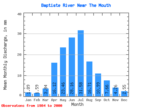
| Statistic | Jan | Feb | Mar | Apr | May | Jun | Jul | Aug | Sep | Oct | Nov | Dec | Annual |
|---|---|---|---|---|---|---|---|---|---|---|---|---|---|
| Mean | 1.89 | 1.61 | 3.83 | 16.12 | 23.45 | 28.16 | 31.57 | 16.71 | 10.99 | 7.66 | 4.26 | 2.55 | 147.12 |
| Standard Deviation | 0.86 | 0.67 | 3.10 | 8.06 | 12.35 | 19.77 | 23.30 | 11.75 | 6.27 | 3.96 | 2.80 | 1.41 | 50.34 |
| Min | 0.87 | 0.71 | 1.05 | 5.41 | 3.15 | 5.72 | 3.43 | 5.47 | 5.18 | 3.57 | 2.11 | 1.53 | 62.10 |
| Max | 3.89 | 2.98 | 13.27 | 32.06 | 54.16 | 84.10 | 92.84 | 51.58 | 25.73 | 18.93 | 12.37 | 7.06 | 275.19 |
| Coefficient of Variation | 0.46 | 0.41 | 0.81 | 0.50 | 0.53 | 0.70 | 0.74 | 0.70 | 0.57 | 0.52 | 0.66 | 0.56 | 0.34 |
 Return to R-Arctic Net Home Page