|
|
|||||||||||||||||
| Point ID: 46 | Downloads | Plots | Site Data | Code: 05AB028 |
|
|
|||||||||||||||||
| Download | |
|---|---|
| Site Descriptor Information | Site Time Series Data |
| Link to all available data | |
| View: | Time Series | All |
| Units: | m3/s |
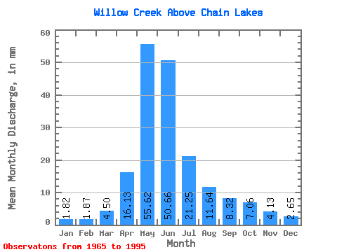
| Statistic | Jan | Feb | Mar | Apr | May | Jun | Jul | Aug | Sep | Oct | Nov | Dec | Annual |
|---|---|---|---|---|---|---|---|---|---|---|---|---|---|
| Mean | 1.82 | 1.89 | 4.49 | 16.12 | 55.60 | 50.65 | 21.24 | 11.63 | 8.32 | 7.05 | 4.13 | 2.65 | 182.47 |
| Standard Deviation | 1.38 | 1.45 | 3.42 | 9.93 | 40.51 | 38.27 | 28.82 | 17.63 | 11.62 | 6.93 | 2.94 | 1.94 | 107.70 |
| Min | 0.00 | 0.01 | 0.17 | 3.97 | 4.48 | 3.65 | 1.29 | 0.31 | 0.24 | 1.06 | 0.86 | 0.33 | 35.31 |
| Max | 5.57 | 6.10 | 13.82 | 49.60 | 149.77 | 163.20 | 110.59 | 72.41 | 59.84 | 26.61 | 12.48 | 8.76 | 509.54 |
| Coefficient of Variation | 0.76 | 0.77 | 0.76 | 0.62 | 0.73 | 0.76 | 1.36 | 1.52 | 1.40 | 0.98 | 0.71 | 0.73 | 0.59 |
 Return to R-Arctic Net Home Page