|
|
|||||||||||||||||
| Point ID: 456 | Downloads | Plots | Site Data | Code: 05DB006 |
|
|
|||||||||||||||||
| Download | |
|---|---|
| Site Descriptor Information | Site Time Series Data |
| Link to all available data | |
| View: | Time Series | All |
| Units: | m3/s |
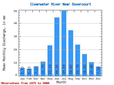
| Statistic | Jan | Feb | Mar | Apr | May | Jun | Jul | Aug | Sep | Oct | Nov | Dec | Annual |
|---|---|---|---|---|---|---|---|---|---|---|---|---|---|
| Mean | 5.93 | 5.48 | 7.17 | 10.79 | 23.14 | 44.30 | 49.59 | 34.62 | 23.79 | 16.65 | 10.48 | 7.00 | 238.58 |
| Standard Deviation | 1.51 | 1.05 | 2.00 | 2.13 | 10.01 | 21.35 | 23.42 | 11.37 | 7.23 | 4.92 | 2.54 | 2.15 | 57.68 |
| Min | 3.19 | 3.76 | 2.33 | 7.66 | 8.91 | 20.57 | 23.54 | 20.41 | 15.11 | 9.45 | 6.80 | 2.25 | 172.42 |
| Max | 8.36 | 7.86 | 12.13 | 15.46 | 48.88 | 112.17 | 113.72 | 68.33 | 39.87 | 35.19 | 17.78 | 11.05 | 342.23 |
| Coefficient of Variation | 0.25 | 0.19 | 0.28 | 0.20 | 0.43 | 0.48 | 0.47 | 0.33 | 0.30 | 0.30 | 0.24 | 0.31 | 0.24 |
 Return to R-Arctic Net Home Page