|
|
|||||||||||||||||
| Point ID: 452 | Downloads | Plots | Site Data | Code: 05DB002 |
|
|
|||||||||||||||||
| Download | |
|---|---|
| Site Descriptor Information | Site Time Series Data |
| Link to all available data | |
| View: | Time Series | All |
| Units: | m3/s |
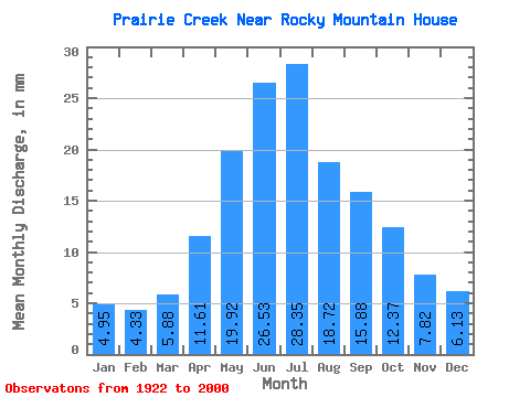
| Statistic | Jan | Feb | Mar | Apr | May | Jun | Jul | Aug | Sep | Oct | Nov | Dec | Annual |
|---|---|---|---|---|---|---|---|---|---|---|---|---|---|
| Mean | 4.95 | 4.37 | 5.88 | 11.61 | 19.92 | 26.53 | 28.35 | 18.72 | 15.88 | 12.37 | 7.82 | 6.13 | 159.62 |
| Standard Deviation | 1.31 | 1.09 | 1.89 | 5.12 | 11.56 | 17.94 | 21.55 | 10.42 | 11.17 | 6.74 | 3.33 | 1.95 | 53.43 |
| Min | 2.77 | 2.70 | 1.24 | 5.67 | 4.37 | 5.43 | 5.77 | 4.08 | 5.01 | 4.77 | 2.24 | 2.51 | 84.29 |
| Max | 9.45 | 7.98 | 10.60 | 29.90 | 55.80 | 75.74 | 114.10 | 57.36 | 67.29 | 35.23 | 19.28 | 11.82 | 301.27 |
| Coefficient of Variation | 0.27 | 0.25 | 0.32 | 0.44 | 0.58 | 0.68 | 0.76 | 0.56 | 0.70 | 0.55 | 0.43 | 0.32 | 0.34 |
 Return to R-Arctic Net Home Page