|
|
|||||||||||||||||
| Point ID: 4453 | Downloads | Plots | Site Data | Code: 05QD027 |
|
|
|||||||||||||||||
| Download | |
|---|---|
| Site Descriptor Information | Site Time Series Data |
| Link to all available data | |
| View: | Time Series | All |
| Units: | m3/s |
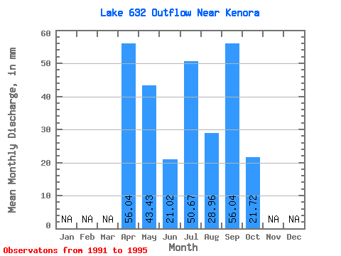
| Statistic | Jan | Feb | Mar | Apr | May | Jun | Jul | Aug | Sep | Oct | Nov | Dec | Annual |
|---|---|---|---|---|---|---|---|---|---|---|---|---|---|
| Mean | 52.54 | 45.24 | 19.27 | 50.66 | 31.85 | 54.64 | 21.71 | ||||||
| Standard Deviation | 42.23 | 28.57 | 15.53 | 32.37 | 27.84 | 36.87 | 11.44 | ||||||
| Min | 14.01 | 21.71 | 7.00 | 7.24 | 0.00 | 7.00 | 7.24 | ||||||
| Max | 112.09 | 86.85 | 42.03 | 86.85 | 72.38 | 105.08 | 36.19 | ||||||
| Coefficient of Variation | 0.80 | 0.63 | 0.81 | 0.64 | 0.87 | 0.68 | 0.53 |
 Return to R-Arctic Net Home Page