|
|
|||||||||||||||||
| Point ID: 4449 | Downloads | Plots | Site Data | Code: 05QD023 |
|
|
|||||||||||||||||
| Download | |
|---|---|
| Site Descriptor Information | Site Time Series Data |
| Link to all available data | |
| View: | Time Series | All |
| Units: | m3/s |
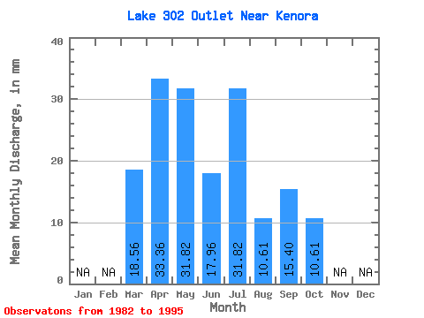
| Statistic | Jan | Feb | Mar | Apr | May | Jun | Jul | Aug | Sep | Oct | Nov | Dec | Annual |
|---|---|---|---|---|---|---|---|---|---|---|---|---|---|
| Mean | 18.56 | 33.56 | 32.63 | 17.57 | 33.04 | 11.22 | 16.19 | 9.79 | |||||
| Standard Deviation | 16.55 | 23.80 | 12.82 | 27.61 | 17.22 | 25.26 | 13.45 | ||||||
| Min | 18.56 | 2.57 | 5.30 | 2.57 | 2.65 | 0.00 | 0.00 | 0.00 | |||||
| Max | 18.56 | 64.16 | 79.55 | 43.63 | 82.20 | 58.33 | 69.29 | 39.77 | |||||
| Coefficient of Variation | 0.49 | 0.73 | 0.73 | 0.84 | 1.54 | 1.56 | 1.37 |
 Return to R-Arctic Net Home Page