|
|
|||||||||||||||||
| Point ID: 4444 | Downloads | Plots | Site Data | Code: 05QD015 |
|
|
|||||||||||||||||
| Download | |
|---|---|
| Site Descriptor Information | Site Time Series Data |
| Link to all available data | |
| View: | Time Series | All |
| Units: | m3/s |
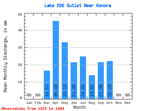
| Statistic | Jan | Feb | Mar | Apr | May | Jun | Jul | Aug | Sep | Oct | Nov | Dec | Annual |
|---|---|---|---|---|---|---|---|---|---|---|---|---|---|
| Mean | 16.57 | 46.50 | 34.31 | 22.01 | 23.53 | 14.46 | 20.23 | 21.43 | |||||
| Standard Deviation | 26.94 | 23.79 | 20.94 | 23.24 | 20.42 | 33.70 | 23.96 | ||||||
| Min | 16.57 | 8.02 | 2.76 | 0.00 | 0.00 | 0.00 | 0.00 | 0.00 | |||||
| Max | 16.57 | 101.54 | 88.35 | 74.82 | 69.02 | 66.26 | 136.28 | 71.78 | |||||
| Coefficient of Variation | 0.58 | 0.69 | 0.95 | 0.99 | 1.41 | 1.67 | 1.12 |
 Return to R-Arctic Net Home Page