|
|
|||||||||||||||||
| Point ID: 4442 | Downloads | Plots | Site Data | Code: 05QD012 |
|
|
|||||||||||||||||
| Download | |
|---|---|
| Site Descriptor Information | Site Time Series Data |
| Link to all available data | |
| View: | Time Series | All |
| Units: | m3/s |
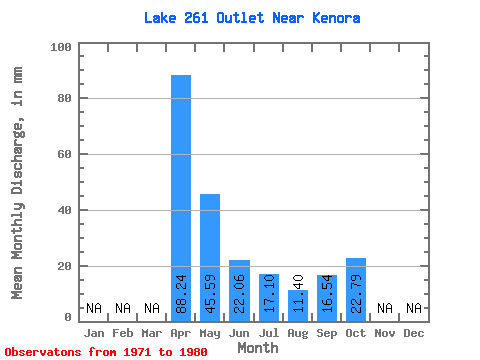
| Statistic | Jan | Feb | Mar | Apr | May | Jun | Jul | Aug | Sep | Oct | Nov | Dec | Annual |
|---|---|---|---|---|---|---|---|---|---|---|---|---|---|
| Mean | 88.24 | 44.95 | 22.67 | 18.36 | 11.40 | 16.55 | 20.26 | ||||||
| Standard Deviation | 45.81 | 34.59 | 22.98 | 21.84 | 21.32 | 20.82 | 27.93 | ||||||
| Min | 22.06 | 0.00 | 0.00 | 0.00 | 0.00 | 0.00 | 0.00 | ||||||
| Max | 170.96 | 102.56 | 55.15 | 68.37 | 62.68 | 60.66 | 74.07 | ||||||
| Coefficient of Variation | 0.52 | 0.77 | 1.01 | 1.19 | 1.87 | 1.26 | 1.38 |
 Return to R-Arctic Net Home Page