|
|
|||||||||||||||||
| Point ID: 4439 | Downloads | Plots | Site Data | Code: 05QD008 |
|
|
|||||||||||||||||
| Download | |
|---|---|
| Site Descriptor Information | Site Time Series Data |
| Link to all available data | |
| View: | Time Series | All |
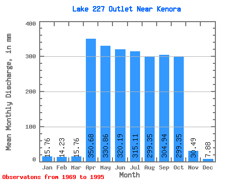
| Units: | m3/s |
| Statistic | Jan | Feb | Mar | Apr | May | Jun | Jul | Aug | Sep | Oct | Nov | Dec | Annual |
|---|---|---|---|---|---|---|---|---|---|---|---|---|---|
| Mean | 15.75 | 14.35 | 15.75 | 348.36 | 331.80 | 317.65 | 318.34 | 302.26 | 301.59 | 302.59 | 26.68 | 7.88 | 456.38 |
| Standard Deviation | 11.14 | 1423.45 | 1402.67 | 1439.40 | 1452.35 | 1447.29 | 1438.19 | 1400.37 | 26.95 | 0.00 | |||
| Min | 15.75 | 14.35 | 7.88 | 0.00 | 7.88 | 0.00 | 0.00 | 0.00 | 0.00 | 0.00 | 7.62 | 7.88 | 456.38 |
| Max | 15.75 | 14.35 | 23.63 | 6876.42 | 6915.54 | 7074.64 | 7136.08 | 7096.70 | 7204.23 | 6876.16 | 45.74 | 7.88 | 456.38 |
| Coefficient of Variation | 0.71 | 4.09 | 4.23 | 4.53 | 4.56 | 4.79 | 4.77 | 4.63 | 1.01 | 0.00 |
 Return to R-Arctic Net Home Page