|
|
|||||||||||||||||
| Point ID: 4436 | Downloads | Plots | Site Data | Code: 05QD002 |
|
|
|||||||||||||||||
| Download | |
|---|---|
| Site Descriptor Information | Site Time Series Data |
| Link to all available data | |
| View: | Time Series | All |
| Units: | m3/s |
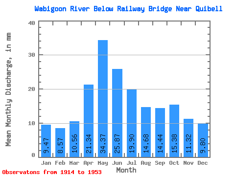
| Statistic | Jan | Feb | Mar | Apr | May | Jun | Jul | Aug | Sep | Oct | Nov | Dec | Annual |
|---|---|---|---|---|---|---|---|---|---|---|---|---|---|
| Mean | 9.47 | 8.65 | 10.56 | 21.34 | 34.37 | 25.86 | 19.89 | 14.68 | 14.44 | 15.38 | 11.32 | 9.80 | 191.57 |
| Standard Deviation | 2.84 | 2.52 | 4.95 | 12.12 | 22.04 | 17.85 | 11.67 | 7.04 | 8.49 | 14.54 | 4.20 | 3.18 | 63.32 |
| Min | 3.82 | 3.14 | 4.01 | 7.55 | 9.92 | 7.92 | 5.56 | 6.31 | 5.34 | 5.81 | 4.38 | 4.10 | 97.13 |
| Max | 15.57 | 13.54 | 27.24 | 54.65 | 105.87 | 87.20 | 49.82 | 31.64 | 53.45 | 95.50 | 23.03 | 16.48 | 318.98 |
| Coefficient of Variation | 0.30 | 0.29 | 0.47 | 0.57 | 0.64 | 0.69 | 0.59 | 0.48 | 0.59 | 0.94 | 0.37 | 0.33 | 0.33 |
 Return to R-Arctic Net Home Page