|
|
|||||||||||||||||
| Point ID: 4430 | Downloads | Plots | Site Data | Code: 05QA005 |
|
|
|||||||||||||||||
| Download | |
|---|---|
| Site Descriptor Information | Site Time Series Data |
| Link to all available data | |
| View: | Time Series | All |
| Units: | m3/s |
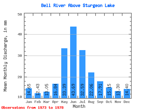
| Statistic | Jan | Feb | Mar | Apr | May | Jun | Jul | Aug | Sep | Oct | Nov | Dec | Annual |
|---|---|---|---|---|---|---|---|---|---|---|---|---|---|
| Mean | 14.64 | 12.53 | 13.04 | 16.84 | 33.38 | 43.69 | 32.59 | 22.06 | 17.91 | 15.15 | 13.30 | 14.40 | 241.34 |
| Standard Deviation | 7.55 | 5.63 | 4.38 | 4.80 | 20.30 | 36.61 | 21.30 | 12.28 | 9.89 | 9.02 | 7.74 | 7.71 | 127.88 |
| Min | 3.16 | 4.22 | 6.67 | 9.87 | 15.73 | 16.87 | 14.74 | 8.98 | 2.89 | 1.18 | 1.34 | 2.28 | 131.58 |
| Max | 21.68 | 17.56 | 17.29 | 22.63 | 68.30 | 105.19 | 67.02 | 39.82 | 29.35 | 25.65 | 22.90 | 21.54 | 450.72 |
| Coefficient of Variation | 0.52 | 0.45 | 0.34 | 0.28 | 0.61 | 0.84 | 0.65 | 0.56 | 0.55 | 0.59 | 0.58 | 0.54 | 0.53 |
 Return to R-Arctic Net Home Page