|
|
|||||||||||||||||
| Point ID: 4411 | Downloads | Plots | Site Data | Code: 05PD024 |
|
|
|||||||||||||||||
| Download | |
|---|---|
| Site Descriptor Information | Site Time Series Data |
| Link to all available data | |
| View: | Time Series | All |
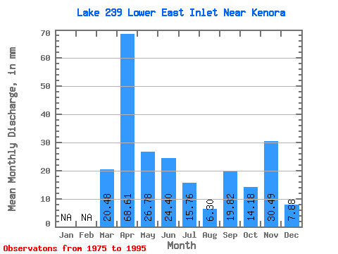
| Units: | m3/s |
| Statistic | Jan | Feb | Mar | Apr | May | Jun | Jul | Aug | Sep | Oct | Nov | Dec | Annual |
|---|---|---|---|---|---|---|---|---|---|---|---|---|---|
| Mean | 19.69 | 69.07 | 27.41 | 23.63 | 16.38 | 6.70 | 19.75 | 14.41 | 30.49 | 7.88 | |||
| Standard Deviation | 25.62 | 42.72 | 17.09 | 20.46 | 15.42 | 9.41 | 25.27 | 15.07 | |||||
| Min | 1.57 | 10.67 | 6.30 | 1.52 | 0.00 | 0.00 | 0.00 | 0.00 | 30.49 | 7.88 | |||
| Max | 37.81 | 146.37 | 59.86 | 70.14 | 55.13 | 26.78 | 89.96 | 47.26 | 30.49 | 7.88 | |||
| Coefficient of Variation | 1.30 | 0.62 | 0.62 | 0.87 | 0.94 | 1.41 | 1.28 | 1.04 |
 Return to R-Arctic Net Home Page