|
|
|||||||||||||||||
| Point ID: 4409 | Downloads | Plots | Site Data | Code: 05PD022 |
|
|
|||||||||||||||||
| Download | |
|---|---|
| Site Descriptor Information | Site Time Series Data |
| Link to all available data | |
| View: | Time Series | All |
| Units: | m3/s |
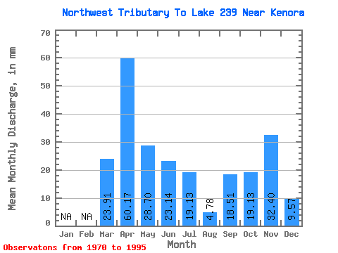
| Statistic | Jan | Feb | Mar | Apr | May | Jun | Jul | Aug | Sep | Oct | Nov | Dec | Annual |
|---|---|---|---|---|---|---|---|---|---|---|---|---|---|
| Mean | 22.32 | 61.38 | 30.98 | 20.93 | 17.73 | 6.97 | 20.64 | 18.53 | 34.71 | 7.17 | |||
| Standard Deviation | 38.65 | 33.33 | 16.81 | 16.68 | 18.95 | 12.29 | 25.24 | 22.58 | 9.82 | 3.38 | |||
| Min | 0.00 | 9.26 | 4.78 | 0.00 | 0.00 | 0.00 | 0.00 | 0.00 | 27.77 | 4.78 | |||
| Max | 66.95 | 129.60 | 66.95 | 55.54 | 62.17 | 47.82 | 87.94 | 86.08 | 41.66 | 9.56 | |||
| Coefficient of Variation | 1.73 | 0.54 | 0.54 | 0.80 | 1.07 | 1.76 | 1.22 | 1.22 | 0.28 | 0.47 |
 Return to R-Arctic Net Home Page