|
|
|||||||||||||||||
| Point ID: 4408 | Downloads | Plots | Site Data | Code: 05PD019 |
|
|
|||||||||||||||||
| Download | |
|---|---|
| Site Descriptor Information | Site Time Series Data |
| Link to all available data | |
| View: | Time Series | All |
| Units: | m3/s |
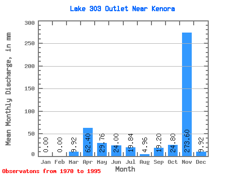
| Statistic | Jan | Feb | Mar | Apr | May | Jun | Jul | Aug | Sep | Oct | Nov | Dec | Annual |
|---|---|---|---|---|---|---|---|---|---|---|---|---|---|
| Mean | 0.00 | 0.00 | 11.57 | 61.40 | 29.34 | 24.00 | 19.01 | 7.12 | 17.53 | 24.59 | 273.60 | 9.92 | 750.04 |
| Standard Deviation | 20.04 | 37.48 | 23.49 | 22.38 | 19.11 | 12.22 | 22.73 | 36.98 | |||||
| Min | 0.00 | 0.00 | 0.00 | 9.60 | 0.00 | 0.00 | 0.00 | 0.00 | 0.00 | 0.00 | 273.60 | 9.92 | 750.04 |
| Max | 0.00 | 0.00 | 34.72 | 120.00 | 94.23 | 76.80 | 59.51 | 44.63 | 76.80 | 138.86 | 273.60 | 9.92 | 750.04 |
| Coefficient of Variation | 1.73 | 0.61 | 0.80 | 0.93 | 1.00 | 1.72 | 1.30 | 1.50 |
 Return to R-Arctic Net Home Page