|
|
|||||||||||||||||
| Point ID: 4407 | Downloads | Plots | Site Data | Code: 05PD017 |
|
|
|||||||||||||||||
| Download | |
|---|---|
| Site Descriptor Information | Site Time Series Data |
| Link to all available data | |
| View: | Time Series | All |
| Units: | m3/s |
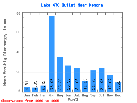
| Statistic | Jan | Feb | Mar | Apr | May | Jun | Jul | Aug | Sep | Oct | Nov | Dec | Annual |
|---|---|---|---|---|---|---|---|---|---|---|---|---|---|
| Mean | 5.34 | 3.71 | 6.41 | 76.18 | 35.41 | 25.64 | 23.28 | 11.48 | 22.16 | 23.41 | 17.20 | 9.75 | 258.21 |
| Standard Deviation | 4.38 | 4.82 | 8.73 | 45.61 | 31.22 | 21.66 | 22.56 | 17.70 | 27.13 | 28.03 | 16.42 | 7.35 | 105.27 |
| Min | 0.00 | 0.00 | 0.00 | 1.55 | 1.60 | 0.00 | 0.00 | 0.00 | 0.00 | 0.00 | 0.00 | 0.00 | 66.14 |
| Max | 16.04 | 17.53 | 38.49 | 149.00 | 117.06 | 97.78 | 75.37 | 60.94 | 97.78 | 89.80 | 52.77 | 28.86 | 422.06 |
| Coefficient of Variation | 0.82 | 1.30 | 1.36 | 0.60 | 0.88 | 0.84 | 0.97 | 1.54 | 1.22 | 1.20 | 0.95 | 0.75 | 0.41 |
 Return to R-Arctic Net Home Page