|
|
|||||||||||||||||
| Point ID: 4405 | Downloads | Plots | Site Data | Code: 05PD015 |
|
|
|||||||||||||||||
| Download | |
|---|---|
| Site Descriptor Information | Site Time Series Data |
| Link to all available data | |
| View: | Time Series | All |
| Units: | m3/s |
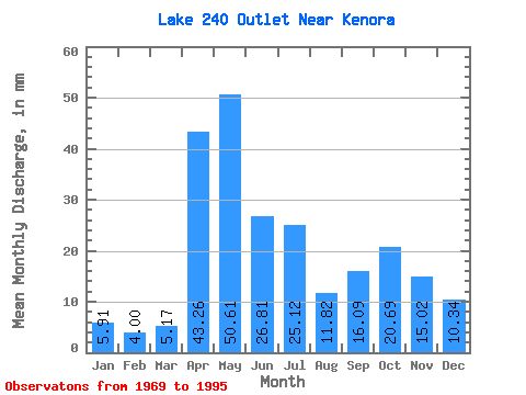
| Statistic | Jan | Feb | Mar | Apr | May | Jun | Jul | Aug | Sep | Oct | Nov | Dec | Annual |
|---|---|---|---|---|---|---|---|---|---|---|---|---|---|
| Mean | 5.97 | 4.04 | 5.23 | 43.22 | 50.78 | 26.76 | 25.07 | 11.95 | 16.00 | 20.74 | 15.09 | 10.39 | 230.11 |
| Standard Deviation | 4.76 | 3.25 | 3.74 | 25.28 | 33.32 | 17.49 | 19.26 | 16.12 | 19.43 | 23.55 | 15.39 | 9.42 | 100.64 |
| Min | 0.00 | 0.00 | 0.00 | 0.71 | 5.54 | 2.50 | 1.85 | 0.00 | 0.00 | 0.00 | 0.00 | 0.00 | 62.76 |
| Max | 12.56 | 9.42 | 12.19 | 86.88 | 131.13 | 74.01 | 73.88 | 62.79 | 66.14 | 73.88 | 48.62 | 26.96 | 401.57 |
| Coefficient of Variation | 0.80 | 0.81 | 0.71 | 0.58 | 0.66 | 0.65 | 0.77 | 1.35 | 1.21 | 1.14 | 1.02 | 0.91 | 0.44 |
 Return to R-Arctic Net Home Page