|
|
|||||||||||||||||
| Point ID: 4371 | Downloads | Plots | Site Data | Code: 04LK001 |
|
|
|||||||||||||||||
| Download | |
|---|---|
| Site Descriptor Information | Site Time Series Data |
| Link to all available data | |
| View: | Time Series | All |
| Units: | m3/s |
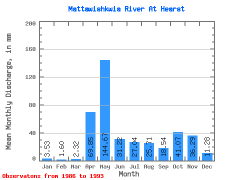
| Statistic | Jan | Feb | Mar | Apr | May | Jun | Jul | Aug | Sep | Oct | Nov | Dec | Annual |
|---|---|---|---|---|---|---|---|---|---|---|---|---|---|
| Mean | 3.53 | 1.61 | 2.32 | 69.84 | 144.65 | 31.22 | 27.04 | 25.71 | 18.55 | 41.06 | 36.28 | 11.27 | 401.21 |
| Standard Deviation | 1.34 | 0.34 | 2.45 | 31.07 | 72.72 | 15.75 | 25.31 | 21.61 | 19.78 | 22.09 | 10.77 | 4.67 | 103.47 |
| Min | 1.92 | 1.11 | 1.15 | 16.26 | 39.23 | 15.21 | 1.24 | 1.09 | 0.74 | 9.63 | 14.35 | 4.37 | 266.77 |
| Max | 5.99 | 2.03 | 8.36 | 109.59 | 260.75 | 55.70 | 75.17 | 51.21 | 60.94 | 75.17 | 45.02 | 18.58 | 557.28 |
| Coefficient of Variation | 0.38 | 0.21 | 1.06 | 0.45 | 0.50 | 0.50 | 0.94 | 0.84 | 1.07 | 0.54 | 0.30 | 0.41 | 0.26 |
 Return to R-Arctic Net Home Page