|
|
|||||||||||||||||
| Point ID: 4358 | Downloads | Plots | Site Data | Code: 04KA001 |
|
|
|||||||||||||||||
| Download | |
|---|---|
| Site Descriptor Information | Site Time Series Data |
| Link to all available data | |
| View: | Time Series | All |
| Units: | m3/s |
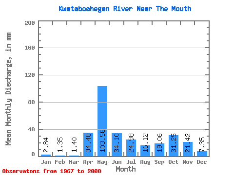
| Statistic | Jan | Feb | Mar | Apr | May | Jun | Jul | Aug | Sep | Oct | Nov | Dec | Annual |
|---|---|---|---|---|---|---|---|---|---|---|---|---|---|
| Mean | 2.84 | 1.36 | 1.40 | 34.48 | 103.56 | 34.10 | 24.98 | 16.11 | 19.06 | 31.25 | 21.42 | 7.34 | 301.40 |
| Standard Deviation | 2.29 | 1.03 | 1.80 | 31.91 | 41.08 | 21.89 | 17.80 | 17.08 | 18.29 | 19.89 | 10.06 | 4.87 | 87.99 |
| Min | 0.60 | 0.46 | 0.29 | 0.89 | 26.34 | 10.12 | 4.10 | 1.17 | 1.69 | 5.00 | 5.21 | 1.56 | 121.12 |
| Max | 13.23 | 5.80 | 10.65 | 100.63 | 200.38 | 89.04 | 69.31 | 72.46 | 81.11 | 110.27 | 48.12 | 27.03 | 481.28 |
| Coefficient of Variation | 0.81 | 0.75 | 1.28 | 0.93 | 0.40 | 0.64 | 0.71 | 1.06 | 0.96 | 0.64 | 0.47 | 0.66 | 0.29 |
 Return to R-Arctic Net Home Page