|
|
|||||||||||||||||
| Point ID: 4346 | Downloads | Plots | Site Data | Code: 04GF001 |
|
|
|||||||||||||||||
| Download | |
|---|---|
| Site Descriptor Information | Site Time Series Data |
| Link to all available data | |
| View: | Time Series | All |
| Units: | m3/s |
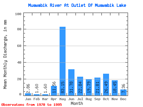
| Statistic | Jan | Feb | Mar | Apr | May | Jun | Jul | Aug | Sep | Oct | Nov | Dec | Annual |
|---|---|---|---|---|---|---|---|---|---|---|---|---|---|
| Mean | 2.85 | 1.61 | 1.60 | 11.56 | 83.14 | 31.78 | 22.83 | 19.79 | 21.81 | 26.48 | 18.45 | 7.36 | 248.35 |
| Standard Deviation | 1.56 | 1.00 | 1.28 | 10.88 | 33.44 | 17.10 | 16.62 | 21.66 | 20.00 | 16.62 | 13.06 | 4.73 | 112.67 |
| Min | 0.38 | 0.14 | 0.14 | 0.48 | 18.00 | 12.64 | 0.92 | 0.44 | 0.25 | 4.24 | 2.63 | 1.45 | 90.18 |
| Max | 5.99 | 4.53 | 5.21 | 33.19 | 177.12 | 79.82 | 65.60 | 93.09 | 84.34 | 58.38 | 46.63 | 16.86 | 552.94 |
| Coefficient of Variation | 0.55 | 0.62 | 0.80 | 0.94 | 0.40 | 0.54 | 0.73 | 1.09 | 0.92 | 0.63 | 0.71 | 0.64 | 0.45 |
 Return to R-Arctic Net Home Page