|
|
|||||||||||||||||
| Point ID: 4337 | Downloads | Plots | Site Data | Code: 04FC001 |
|
|
|||||||||||||||||
| Download | |
|---|---|
| Site Descriptor Information | Site Time Series Data |
| Link to all available data | |
| View: | Time Series | All |
| Units: | m3/s |
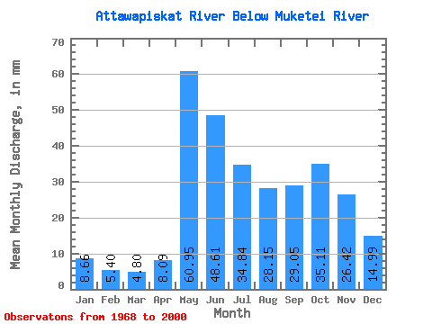
| Statistic | Jan | Feb | Mar | Apr | May | Jun | Jul | Aug | Sep | Oct | Nov | Dec | Annual |
|---|---|---|---|---|---|---|---|---|---|---|---|---|---|
| Mean | 8.66 | 5.45 | 4.80 | 8.09 | 60.94 | 48.62 | 34.84 | 28.14 | 29.05 | 35.11 | 26.42 | 14.99 | 303.52 |
| Standard Deviation | 2.94 | 1.50 | 1.11 | 4.70 | 25.08 | 23.77 | 17.20 | 17.89 | 18.27 | 19.56 | 13.43 | 6.59 | 93.25 |
| Min | 4.37 | 3.32 | 3.31 | 3.46 | 23.88 | 14.26 | 11.75 | 8.85 | 5.67 | 7.74 | 5.70 | 3.92 | 154.64 |
| Max | 14.73 | 8.27 | 7.74 | 23.47 | 134.64 | 127.44 | 91.50 | 81.83 | 61.56 | 76.62 | 58.46 | 32.81 | 477.39 |
| Coefficient of Variation | 0.34 | 0.28 | 0.23 | 0.58 | 0.41 | 0.49 | 0.49 | 0.64 | 0.63 | 0.56 | 0.51 | 0.44 | 0.31 |
 Return to R-Arctic Net Home Page