|
|
|||||||||||||||||
| Point ID: 415 | Downloads | Plots | Site Data | Code: 05CH007 |
|
|
|||||||||||||||||
| Download | |
|---|---|
| Site Descriptor Information | Site Time Series Data |
| Link to all available data | |
| View: | Time Series | All |
| Units: | m3/s |
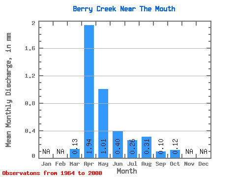
| Statistic | Jan | Feb | Mar | Apr | May | Jun | Jul | Aug | Sep | Oct | Nov | Dec | Annual |
|---|---|---|---|---|---|---|---|---|---|---|---|---|---|
| Mean | 0.09 | 1.24 | 0.65 | 0.26 | 0.17 | 0.20 | 0.06 | 0.08 | |||||
| Standard Deviation | 0.17 | 2.41 | 1.52 | 0.21 | 0.14 | 0.17 | 0.09 | 0.11 | |||||
| Min | 0.00 | 0.00 | 0.00 | 0.00 | 0.00 | 0.00 | 0.00 | 0.00 | |||||
| Max | 1.04 | 9.41 | 8.57 | 0.85 | 0.48 | 0.58 | 0.48 | 0.54 | |||||
| Coefficient of Variation | 2.02 | 1.94 | 2.34 | 0.84 | 0.88 | 0.86 | 1.43 | 1.35 |
 Return to R-Arctic Net Home Page