|
|
|||||||||||||||||
| Point ID: 403 | Downloads | Plots | Site Data | Code: 05CE020 |
|
|
|||||||||||||||||
| Download | |
|---|---|
| Site Descriptor Information | Site Time Series Data |
| Link to all available data | |
| View: | Time Series | All |
| Units: | m3/s |
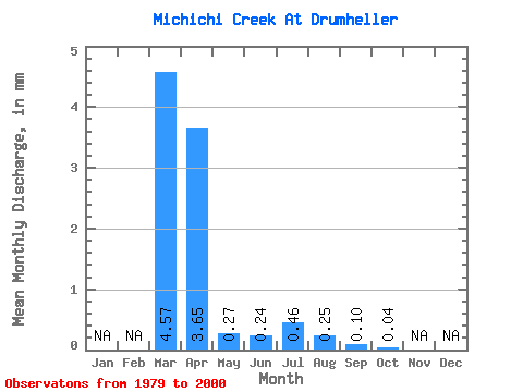
| Statistic | Jan | Feb | Mar | Apr | May | Jun | Jul | Aug | Sep | Oct | Nov | Dec | Annual |
|---|---|---|---|---|---|---|---|---|---|---|---|---|---|
| Mean | 2.88 | 2.31 | 0.17 | 0.15 | 0.29 | 0.16 | 0.07 | 0.03 | |||||
| Standard Deviation | 4.38 | 3.08 | 0.14 | 0.14 | 0.72 | 0.23 | 0.12 | 0.09 | |||||
| Min | 0.05 | 0.01 | 0.00 | 0.00 | 0.00 | 0.00 | 0.00 | 0.00 | |||||
| Max | 16.16 | 8.94 | 0.46 | 0.45 | 3.36 | 0.81 | 0.51 | 0.42 | |||||
| Coefficient of Variation | 1.52 | 1.34 | 0.80 | 0.93 | 2.49 | 1.46 | 1.73 | 3.48 |
 Return to R-Arctic Net Home Page