|
|
|||||||||||||||||
| Point ID: 401 | Downloads | Plots | Site Data | Code: 05CE018 |
|
|
|||||||||||||||||
| Download | |
|---|---|
| Site Descriptor Information | Site Time Series Data |
| Link to all available data | |
| View: | Time Series | All |
| Units: | m3/s |
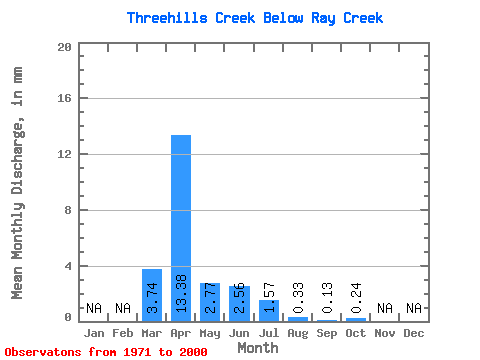
| Statistic | Jan | Feb | Mar | Apr | May | Jun | Jul | Aug | Sep | Oct | Nov | Dec | Annual |
|---|---|---|---|---|---|---|---|---|---|---|---|---|---|
| Mean | 2.93 | 10.46 | 2.16 | 2.00 | 1.22 | 0.25 | 0.11 | 0.19 | |||||
| Standard Deviation | 3.36 | 13.65 | 2.35 | 6.10 | 3.15 | 0.58 | 0.30 | 0.44 | |||||
| Min | 0.00 | 0.53 | 0.01 | 0.04 | 0.00 | 0.00 | 0.00 | 0.00 | |||||
| Max | 11.98 | 54.47 | 11.17 | 33.55 | 16.86 | 3.09 | 1.63 | 2.37 | |||||
| Coefficient of Variation | 1.15 | 1.30 | 1.08 | 3.04 | 2.59 | 2.29 | 2.74 | 2.36 |
 Return to R-Arctic Net Home Page