|
|
|||||||||||||||||
| Point ID: 399 | Downloads | Plots | Site Data | Code: 05CE015 |
|
|
|||||||||||||||||
| Download | |
|---|---|
| Site Descriptor Information | Site Time Series Data |
| Link to all available data | |
| View: | Time Series | All |
| Units: | m3/s |
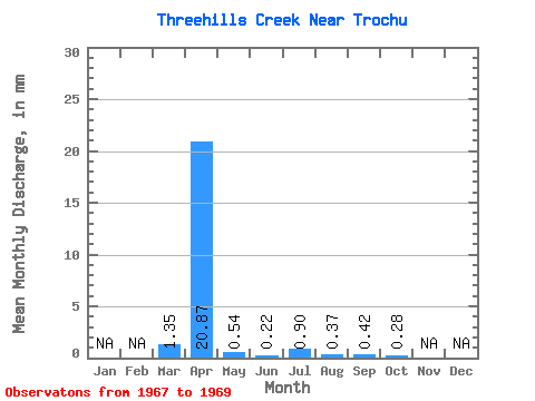
| Statistic | Jan | Feb | Mar | Apr | May | Jun | Jul | Aug | Sep | Oct | Nov | Dec | Annual |
|---|---|---|---|---|---|---|---|---|---|---|---|---|---|
| Mean | 1.14 | 17.68 | 0.46 | 0.19 | 0.77 | 0.31 | 0.36 | 0.24 | |||||
| Standard Deviation | 1.55 | 23.74 | 0.50 | 0.15 | 0.61 | 0.34 | 0.50 | 0.17 | |||||
| Min | 0.05 | 0.89 | 0.10 | 0.08 | 0.08 | 0.02 | 0.04 | 0.05 | |||||
| Max | 2.24 | 34.47 | 0.81 | 0.29 | 1.22 | 0.68 | 0.94 | 0.40 | |||||
| Coefficient of Variation | 1.36 | 1.34 | 1.11 | 0.81 | 0.79 | 1.08 | 1.41 | 0.72 |
 Return to R-Arctic Net Home Page