|
|
|||||||||||||||||
| Point ID: 398 | Downloads | Plots | Site Data | Code: 05CE013 |
|
|
|||||||||||||||||
| Download | |
|---|---|
| Site Descriptor Information | Site Time Series Data |
| Link to all available data | |
| View: | Time Series | All |
| Units: | m3/s |
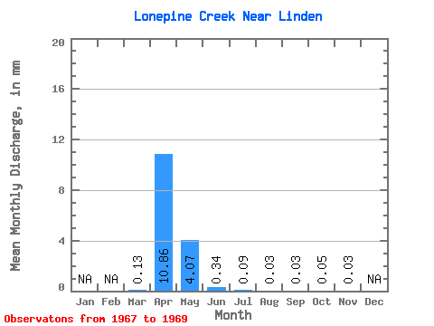
| Statistic | Jan | Feb | Mar | Apr | May | Jun | Jul | Aug | Sep | Oct | Nov | Dec | Annual |
|---|---|---|---|---|---|---|---|---|---|---|---|---|---|
| Mean | 0.12 | 9.72 | 3.64 | 0.31 | 0.08 | 0.03 | 0.03 | 0.05 | 0.03 | ||||
| Standard Deviation | 0.20 | 9.94 | 6.00 | 0.36 | 0.04 | 0.01 | 0.03 | 0.03 | |||||
| Min | 0.00 | 0.07 | 0.07 | 0.06 | 0.04 | 0.01 | 0.00 | 0.01 | 0.03 | ||||
| Max | 0.35 | 19.93 | 10.56 | 0.73 | 0.12 | 0.04 | 0.06 | 0.07 | 0.03 | ||||
| Coefficient of Variation | 1.62 | 1.02 | 1.65 | 1.19 | 0.45 | 0.60 | 1.28 | 0.65 |
 Return to R-Arctic Net Home Page