|
|
|||||||||||||||||
| Point ID: 396 | Downloads | Plots | Site Data | Code: 05CE011 |
|
|
|||||||||||||||||
| Download | |
|---|---|
| Site Descriptor Information | Site Time Series Data |
| Link to all available data | |
| View: | Time Series | All |
| Units: | m3/s |
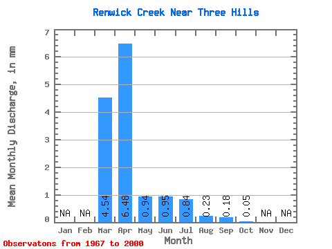
| Statistic | Jan | Feb | Mar | Apr | May | Jun | Jul | Aug | Sep | Oct | Nov | Dec | Annual |
|---|---|---|---|---|---|---|---|---|---|---|---|---|---|
| Mean | 4.55 | 6.48 | 0.94 | 0.97 | 0.84 | 0.23 | 0.18 | 0.04 | |||||
| Standard Deviation | 7.06 | 11.47 | 1.25 | 2.17 | 2.51 | 0.64 | 0.67 | 0.09 | |||||
| Min | 0.00 | 0.04 | 0.00 | 0.00 | 0.00 | 0.00 | 0.00 | 0.00 | |||||
| Max | 33.05 | 45.31 | 5.76 | 8.61 | 13.06 | 3.32 | 3.49 | 0.38 | |||||
| Coefficient of Variation | 1.55 | 1.77 | 1.34 | 2.24 | 2.99 | 2.84 | 3.78 | 2.05 |
 Return to R-Arctic Net Home Page