|
|
|||||||||||||||||
| Point ID: 39 | Downloads | Plots | Site Data | Code: 05AB021 |
|
|
|||||||||||||||||
| Download | |
|---|---|
| Site Descriptor Information | Site Time Series Data |
| Link to all available data | |
| View: | Time Series | All |
| Units: | m3/s |
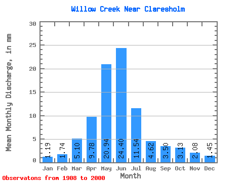
| Statistic | Jan | Feb | Mar | Apr | May | Jun | Jul | Aug | Sep | Oct | Nov | Dec | Annual |
|---|---|---|---|---|---|---|---|---|---|---|---|---|---|
| Mean | 1.13 | 1.66 | 4.84 | 9.27 | 19.85 | 23.14 | 10.94 | 4.38 | 3.32 | 2.97 | 1.97 | 1.38 | 84.72 |
| Standard Deviation | 0.79 | 1.58 | 4.14 | 7.81 | 16.71 | 25.75 | 13.91 | 5.66 | 5.31 | 3.52 | 1.56 | 0.98 | 62.83 |
| Min | 0.06 | 0.06 | 0.30 | 0.85 | 0.62 | 0.98 | 0.21 | 0.12 | 0.19 | 0.39 | 0.39 | 0.19 | 10.44 |
| Max | 4.20 | 8.48 | 18.12 | 31.06 | 83.34 | 138.76 | 57.02 | 35.09 | 29.27 | 20.06 | 8.47 | 5.38 | 259.71 |
| Coefficient of Variation | 0.69 | 0.95 | 0.85 | 0.84 | 0.84 | 1.11 | 1.27 | 1.29 | 1.60 | 1.19 | 0.79 | 0.71 | 0.74 |
 Return to R-Arctic Net Home Page