|
|
|||||||||||||||||
| Point ID: 387 | Downloads | Plots | Site Data | Code: 05CE002 |
|
|
|||||||||||||||||
| Download | |
|---|---|
| Site Descriptor Information | Site Time Series Data |
| Link to all available data | |
| View: | Time Series | All |
| Units: | m3/s |
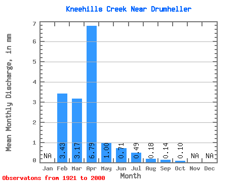
| Statistic | Jan | Feb | Mar | Apr | May | Jun | Jul | Aug | Sep | Oct | Nov | Dec | Annual |
|---|---|---|---|---|---|---|---|---|---|---|---|---|---|
| Mean | 3.07 | 2.81 | 6.03 | 0.89 | 0.63 | 0.44 | 0.16 | 0.12 | 0.09 | ||||
| Standard Deviation | 4.15 | 9.67 | 1.60 | 1.11 | 0.80 | 0.17 | 0.17 | 0.19 | |||||
| Min | 3.07 | 0.00 | 0.09 | 0.00 | 0.00 | 0.00 | 0.00 | 0.00 | 0.00 | ||||
| Max | 3.07 | 17.85 | 40.53 | 8.79 | 5.54 | 4.66 | 0.90 | 0.60 | 1.33 | ||||
| Coefficient of Variation | 1.48 | 1.60 | 1.81 | 1.76 | 1.82 | 1.08 | 1.43 | 2.15 |
 Return to R-Arctic Net Home Page