|
|
|||||||||||||||||
| Point ID: 384 | Downloads | Plots | Site Data | Code: 05CD007 |
|
|
|||||||||||||||||
| Download | |
|---|---|
| Site Descriptor Information | Site Time Series Data |
| Link to all available data | |
| View: | Time Series | All |
| Units: | m3/s |
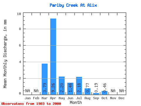
| Statistic | Jan | Feb | Mar | Apr | May | Jun | Jul | Aug | Sep | Oct | Nov | Dec | Annual |
|---|---|---|---|---|---|---|---|---|---|---|---|---|---|
| Mean | 3.59 | 8.77 | 2.08 | 1.38 | 2.07 | 0.73 | 0.18 | 0.43 | |||||
| Standard Deviation | 3.88 | 6.24 | 1.27 | 1.39 | 2.19 | 1.07 | 0.19 | 0.32 | |||||
| Min | 0.01 | 1.56 | 0.23 | 0.16 | 0.01 | 0.01 | 0.01 | 0.01 | |||||
| Max | 13.73 | 19.98 | 5.36 | 5.59 | 7.75 | 4.16 | 0.55 | 1.29 | |||||
| Coefficient of Variation | 1.08 | 0.71 | 0.61 | 1.01 | 1.06 | 1.45 | 1.04 | 0.74 |
 Return to R-Arctic Net Home Page