|
|
|||||||||||||||||
| Point ID: 380 | Downloads | Plots | Site Data | Code: 05CC012 |
|
|
|||||||||||||||||
| Download | |
|---|---|
| Site Descriptor Information | Site Time Series Data |
| Link to all available data | |
| View: | Time Series | All |
| Units: | m3/s |
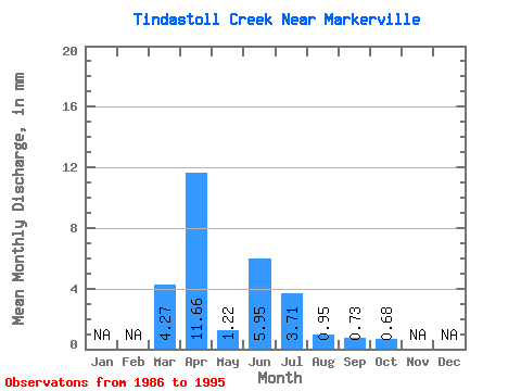
| Statistic | Jan | Feb | Mar | Apr | May | Jun | Jul | Aug | Sep | Oct | Nov | Dec | Annual |
|---|---|---|---|---|---|---|---|---|---|---|---|---|---|
| Mean | 4.14 | 11.33 | 1.18 | 5.79 | 3.60 | 0.92 | 0.72 | 0.66 | |||||
| Standard Deviation | 4.89 | 8.30 | 0.89 | 14.97 | 6.32 | 1.47 | 1.04 | 1.31 | |||||
| Min | 0.00 | 0.89 | 0.19 | 0.11 | 0.02 | 0.13 | 0.00 | 0.02 | |||||
| Max | 13.71 | 23.18 | 2.75 | 45.63 | 18.03 | 4.96 | 3.30 | 4.34 | |||||
| Coefficient of Variation | 1.18 | 0.73 | 0.75 | 2.59 | 1.75 | 1.59 | 1.45 | 1.99 |
 Return to R-Arctic Net Home Page