|
|
|||||||||||||||||
| Point ID: 3682 | Downloads | Plots | Site Data | Code: 10QC002 |
|
|
|||||||||||||||||
| Download | |
|---|---|
| Site Descriptor Information | Site Time Series Data |
| Link to all available data | |
| View: | Time Series | All |
| Units: | m3/s |
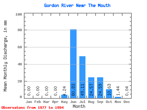
| Statistic | Jan | Feb | Mar | Apr | May | Jun | Jul | Aug | Sep | Oct | Nov | Dec | Annual |
|---|---|---|---|---|---|---|---|---|---|---|---|---|---|
| Mean | 0.00 | 0.00 | 0.00 | 0.00 | 4.24 | 80.83 | 49.10 | 24.57 | 24.59 | 10.63 | 1.44 | 0.04 | 186.54 |
| Standard Deviation | 0.01 | 0.00 | 0.00 | 0.00 | 11.48 | 32.95 | 20.07 | 11.96 | 12.96 | 5.54 | 0.93 | 0.07 | 36.68 |
| Min | 0.00 | 0.00 | 0.00 | 0.00 | 0.00 | 22.36 | 21.35 | 13.09 | 6.23 | 2.99 | 0.02 | 0.00 | 126.08 |
| Max | 0.04 | 0.00 | 0.00 | 0.00 | 46.38 | 145.53 | 87.52 | 53.38 | 54.21 | 21.88 | 3.37 | 0.23 | 264.94 |
| Coefficient of Variation | 3.32 | 2.71 | 0.41 | 0.41 | 0.49 | 0.53 | 0.52 | 0.65 | 1.74 | 0.20 |
 Return to R-Arctic Net Home Page