|
|
|||||||||||||||||
| Point ID: 367 | Downloads | Plots | Site Data | Code: 05CB001 |
|
|
|||||||||||||||||
| Download | |
|---|---|
| Site Descriptor Information | Site Time Series Data |
| Link to all available data | |
| View: | Time Series | All |
| Units: | m3/s |
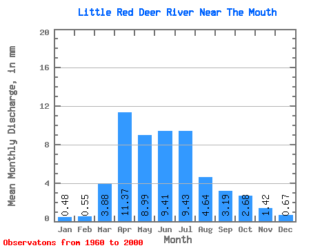
| Statistic | Jan | Feb | Mar | Apr | May | Jun | Jul | Aug | Sep | Oct | Nov | Dec | Annual |
|---|---|---|---|---|---|---|---|---|---|---|---|---|---|
| Mean | 0.46 | 0.53 | 3.74 | 10.97 | 8.67 | 9.08 | 9.09 | 4.47 | 3.07 | 2.59 | 1.37 | 0.65 | 54.77 |
| Standard Deviation | 0.37 | 0.58 | 3.72 | 9.15 | 6.61 | 6.98 | 9.37 | 3.79 | 2.66 | 2.42 | 0.83 | 0.45 | 27.15 |
| Min | 0.02 | 0.00 | 0.07 | 2.66 | 1.51 | 1.33 | 0.29 | 0.27 | 0.61 | 0.65 | 0.28 | 0.16 | 14.49 |
| Max | 1.56 | 2.89 | 17.57 | 35.23 | 32.74 | 33.62 | 37.24 | 17.78 | 13.26 | 15.27 | 4.35 | 2.03 | 134.94 |
| Coefficient of Variation | 0.80 | 1.10 | 0.99 | 0.83 | 0.76 | 0.77 | 1.03 | 0.85 | 0.87 | 0.94 | 0.61 | 0.70 | 0.50 |
 Return to R-Arctic Net Home Page