|
|
|||||||||||||||||
| Point ID: 3668 | Downloads | Plots | Site Data | Code: 10NC001 |
|
|
|||||||||||||||||
| Download | |
|---|---|
| Site Descriptor Information | Site Time Series Data |
| Link to all available data | |
| View: | Time Series | All |
| Units: | m3/s |
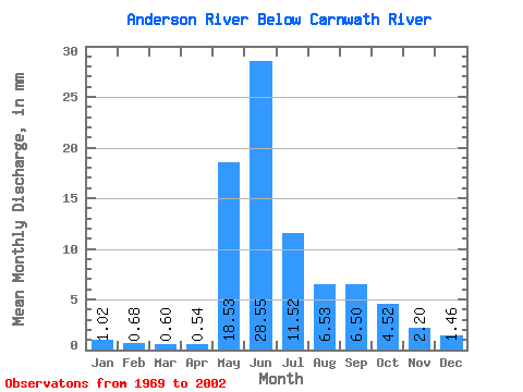
| Statistic | Jan | Feb | Mar | Apr | May | Jun | Jul | Aug | Sep | Oct | Nov | Dec | Annual |
|---|---|---|---|---|---|---|---|---|---|---|---|---|---|
| Mean | 1.02 | 0.69 | 0.60 | 0.54 | 18.53 | 28.55 | 11.51 | 6.53 | 6.50 | 4.52 | 2.20 | 1.46 | 79.35 |
| Standard Deviation | 0.48 | 0.27 | 0.23 | 0.21 | 12.40 | 13.69 | 4.70 | 3.04 | 4.33 | 3.09 | 1.47 | 0.83 | 27.47 |
| Min | 0.55 | 0.41 | 0.23 | 0.21 | 1.57 | 12.25 | 5.47 | 2.73 | 2.16 | 1.39 | 0.73 | 0.70 | 36.17 |
| Max | 2.29 | 1.42 | 1.17 | 1.05 | 47.57 | 69.98 | 21.88 | 13.65 | 22.74 | 13.46 | 6.40 | 3.76 | 132.39 |
| Coefficient of Variation | 0.47 | 0.40 | 0.38 | 0.39 | 0.67 | 0.48 | 0.41 | 0.47 | 0.67 | 0.68 | 0.67 | 0.57 | 0.35 |
 Return to R-Arctic Net Home Page