|
|
|||||||||||||||||
| Point ID: 3661 | Downloads | Plots | Site Data | Code: 10LD002 |
|
|
|||||||||||||||||
| Download | |
|---|---|
| Site Descriptor Information | Site Time Series Data |
| Link to all available data | |
| View: | Time Series | All |
| Units: | m3/s |
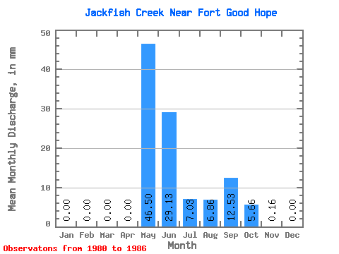
| Statistic | Jan | Feb | Mar | Apr | May | Jun | Jul | Aug | Sep | Oct | Nov | Dec | Annual |
|---|---|---|---|---|---|---|---|---|---|---|---|---|---|
| Mean | 0.00 | 0.00 | 0.00 | 0.00 | 46.48 | 29.16 | 7.00 | 6.86 | 12.52 | 5.67 | 0.15 | 0.00 | 116.16 |
| Standard Deviation | 0.00 | 0.00 | 0.00 | 0.00 | 25.57 | 11.43 | 5.73 | 8.00 | 19.85 | 8.35 | 0.26 | 0.00 | 34.32 |
| Min | 0.00 | 0.00 | 0.00 | 0.00 | 20.48 | 13.56 | 1.79 | 0.60 | 1.73 | 0.98 | 0.00 | 0.00 | 61.21 |
| Max | 0.00 | 0.00 | 0.00 | 0.00 | 91.54 | 41.21 | 17.58 | 18.86 | 54.81 | 24.05 | 0.62 | 0.00 | 142.83 |
| Coefficient of Variation | 0.55 | 0.39 | 0.82 | 1.17 | 1.59 | 1.47 | 1.70 | 0.29 |
 Return to R-Arctic Net Home Page