|
|
|||||||||||||||||
| Point ID: 3659 | Downloads | Plots | Site Data | Code: 10LC010 |
|
|
|||||||||||||||||
| Download | |
|---|---|
| Site Descriptor Information | Site Time Series Data |
| Link to all available data | |
| View: | Time Series | All |
| Units: | m3/s |
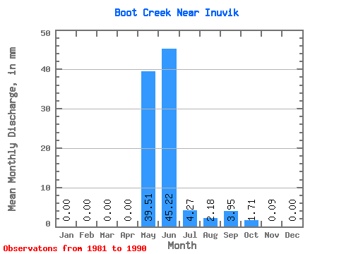
| Statistic | Jan | Feb | Mar | Apr | May | Jun | Jul | Aug | Sep | Oct | Nov | Dec | Annual |
|---|---|---|---|---|---|---|---|---|---|---|---|---|---|
| Mean | 0.00 | 0.00 | 0.00 | 0.00 | 39.54 | 45.25 | 4.28 | 2.18 | 3.94 | 1.71 | 0.07 | 0.00 | 96.85 |
| Standard Deviation | 0.00 | 0.00 | 0.00 | 0.00 | 32.52 | 26.05 | 4.94 | 3.36 | 4.71 | 2.07 | 0.15 | 0.00 | 38.01 |
| Min | 0.00 | 0.00 | 0.00 | 0.00 | 0.00 | 12.50 | 1.04 | 0.00 | 0.00 | 0.00 | 0.00 | 0.00 | 40.76 |
| Max | 0.00 | 0.00 | 0.00 | 0.00 | 111.11 | 93.75 | 16.43 | 10.45 | 12.87 | 6.17 | 0.46 | 0.00 | 167.22 |
| Coefficient of Variation | 0.82 | 0.58 | 1.15 | 1.54 | 1.20 | 1.21 | 2.11 | 0.39 |
 Return to R-Arctic Net Home Page