|
|
|||||||||||||||||
| Point ID: 3653 | Downloads | Plots | Site Data | Code: 10LC003 |
|
|
|||||||||||||||||
| Download | |
|---|---|
| Site Descriptor Information | Site Time Series Data |
| Link to all available data | |
| View: | Time Series | All |
| Units: | m3/s |
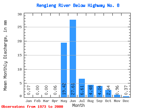
| Statistic | Jan | Feb | Mar | Apr | May | Jun | Jul | Aug | Sep | Oct | Nov | Dec | Annual |
|---|---|---|---|---|---|---|---|---|---|---|---|---|---|
| Mean | 0.07 | 0.00 | 0.00 | 0.06 | 19.41 | 27.61 | 6.61 | 4.48 | 4.04 | 2.64 | 0.96 | 0.37 | 68.72 |
| Standard Deviation | 0.09 | 0.01 | 0.00 | 0.17 | 12.85 | 16.27 | 5.00 | 7.07 | 3.84 | 2.16 | 0.69 | 0.31 | 28.30 |
| Min | 0.00 | 0.00 | 0.00 | 0.00 | 0.09 | 5.94 | 0.99 | 0.27 | 0.19 | 0.09 | 0.00 | 0.00 | 10.97 |
| Max | 0.34 | 0.02 | 0.00 | 0.79 | 54.58 | 60.15 | 20.65 | 33.12 | 16.34 | 9.71 | 2.73 | 1.32 | 125.56 |
| Coefficient of Variation | 1.40 | 2.25 | 3.04 | 0.66 | 0.59 | 0.76 | 1.58 | 0.95 | 0.82 | 0.72 | 0.83 | 0.41 |
 Return to R-Arctic Net Home Page