|
|
|||||||||||||||||
| Point ID: 3639 | Downloads | Plots | Site Data | Code: 10JD001 |
|
|
|||||||||||||||||
| Download | |
|---|---|
| Site Descriptor Information | Site Time Series Data |
| Link to all available data | |
| View: | Time Series | All |
| Units: | m3/s |
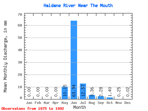
| Statistic | Jan | Feb | Mar | Apr | May | Jun | Jul | Aug | Sep | Oct | Nov | Dec | Annual |
|---|---|---|---|---|---|---|---|---|---|---|---|---|---|
| Mean | 0.00 | 0.00 | 0.00 | 0.01 | 10.15 | 63.94 | 12.57 | 3.36 | 2.28 | 1.40 | 0.25 | 0.02 | 96.17 |
| Standard Deviation | 0.00 | 0.00 | 0.00 | 0.02 | 12.65 | 24.73 | 3.97 | 2.35 | 2.33 | 1.56 | 0.30 | 0.04 | 37.84 |
| Min | 0.00 | 0.00 | 0.00 | 0.00 | 0.00 | 31.84 | 6.21 | 0.71 | 0.56 | 0.10 | 0.00 | 0.00 | 42.59 |
| Max | 0.00 | 0.00 | 0.00 | 0.06 | 35.62 | 99.34 | 22.23 | 10.88 | 8.68 | 6.20 | 1.05 | 0.15 | 141.21 |
| Coefficient of Variation | 3.46 | 1.25 | 0.39 | 0.32 | 0.70 | 1.02 | 1.12 | 1.18 | 2.18 | 0.39 |
 Return to R-Arctic Net Home Page