|
|
|||||||||||||||||
| Point ID: 363 | Downloads | Plots | Site Data | Code: 05CA004 |
|
|
|||||||||||||||||
| Download | |
|---|---|
| Site Descriptor Information | Site Time Series Data |
| Link to all available data | |
| View: | Time Series | All |
| Units: | m3/s |
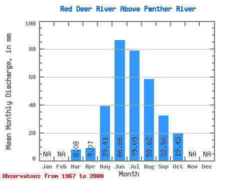
| Statistic | Jan | Feb | Mar | Apr | May | Jun | Jul | Aug | Sep | Oct | Nov | Dec | Annual |
|---|---|---|---|---|---|---|---|---|---|---|---|---|---|
| Mean | 8.08 | 9.06 | 39.40 | 86.66 | 79.07 | 58.61 | 32.49 | 19.42 | |||||
| Standard Deviation | 0.04 | 1.61 | 15.04 | 27.04 | 19.82 | 12.55 | 5.93 | 3.10 | |||||
| Min | 8.05 | 7.22 | 16.39 | 45.73 | 46.96 | 40.41 | 22.26 | 14.29 | |||||
| Max | 8.11 | 14.63 | 78.26 | 156.73 | 131.48 | 92.78 | 45.73 | 28.46 | |||||
| Coefficient of Variation | 0.01 | 0.18 | 0.38 | 0.31 | 0.25 | 0.21 | 0.18 | 0.16 |
 Return to R-Arctic Net Home Page