|
|
|||||||||||||||||
| Point ID: 3626 | Downloads | Plots | Site Data | Code: 10HA002 |
|
|
|||||||||||||||||
| Download | |
|---|---|
| Site Descriptor Information | Site Time Series Data |
| Link to all available data | |
| View: | Time Series | All |
| Units: | m3/s |
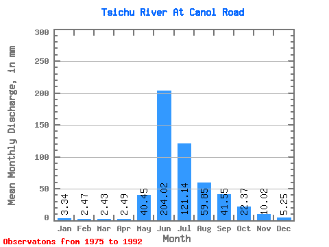
| Statistic | Jan | Feb | Mar | Apr | May | Jun | Jul | Aug | Sep | Oct | Nov | Dec | Annual |
|---|---|---|---|---|---|---|---|---|---|---|---|---|---|
| Mean | 3.33 | 2.50 | 2.43 | 2.48 | 40.44 | 204.02 | 121.12 | 59.85 | 41.56 | 22.36 | 10.03 | 5.25 | 514.64 |
| Standard Deviation | 1.50 | 1.36 | 1.33 | 1.20 | 33.07 | 56.76 | 34.37 | 13.07 | 25.17 | 10.59 | 4.88 | 2.00 | 91.86 |
| Min | 0.73 | 0.62 | 0.77 | 0.48 | 5.42 | 84.51 | 65.67 | 35.09 | 21.66 | 6.32 | 3.55 | 2.63 | 310.16 |
| Max | 6.09 | 5.18 | 5.26 | 3.91 | 116.90 | 306.54 | 183.43 | 88.29 | 130.19 | 44.02 | 19.17 | 9.59 | 731.44 |
| Coefficient of Variation | 0.45 | 0.54 | 0.55 | 0.48 | 0.82 | 0.28 | 0.28 | 0.22 | 0.61 | 0.47 | 0.49 | 0.38 | 0.18 |
 Return to R-Arctic Net Home Page