|
|
|||||||||||||||||
| Point ID: 3622 | Downloads | Plots | Site Data | Other Close Sites | Code: 10GC001 |
|
|
|||||||||||||||||
| Download | |
|---|---|
| Site Descriptor Information | Site Time Series Data |
| Link to all available data | |
| View: | Time Series | All |
| Units: | m3/s |
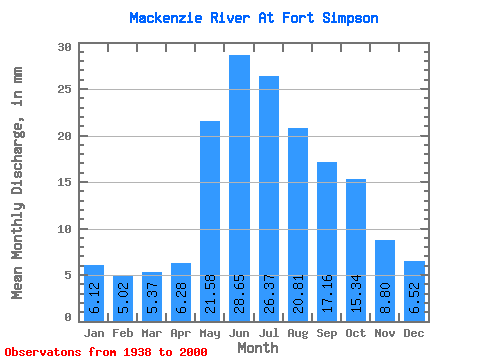
| Statistic | Jan | Feb | Mar | Apr | May | Jun | Jul | Aug | Sep | Oct | Nov | Dec | Annual |
|---|---|---|---|---|---|---|---|---|---|---|---|---|---|
| Mean | 6.12 | 5.07 | 5.37 | 6.28 | 21.58 | 28.65 | 26.37 | 20.81 | 17.16 | 15.34 | 8.80 | 6.51 | 168.21 |
| Standard Deviation | 1.27 | 1.13 | 1.21 | 1.60 | 4.13 | 5.11 | 4.95 | 4.07 | 3.58 | 2.79 | 1.87 | 1.19 | 20.78 |
| Min | 4.34 | 3.21 | 3.35 | 3.80 | 14.11 | 19.04 | 16.43 | 11.11 | 6.20 | 5.50 | 5.22 | 4.58 | 125.04 |
| Max | 9.03 | 7.97 | 8.58 | 11.59 | 29.52 | 40.21 | 39.43 | 35.64 | 30.41 | 21.51 | 14.63 | 10.29 | 223.12 |
| Coefficient of Variation | 0.21 | 0.22 | 0.23 | 0.26 | 0.19 | 0.18 | 0.19 | 0.20 | 0.21 | 0.18 | 0.21 | 0.18 | 0.12 |
| Other Close Sites | ||||||
|---|---|---|---|---|---|---|
| PointID | Latitude | Longitude | Drainage Area | Source | Name | |
| 3605 | "LIARD RIVER NEAR THE MOUTH" | 61.74 | 1612368 | Hydat | ||
 Return to R-Arctic Net Home Page