|
|
|||||||||||||||||
| Point ID: 3620 | Downloads | Plots | Site Data | Code: 10GB005 |
|
|
|||||||||||||||||
| Download | |
|---|---|
| Site Descriptor Information | Site Time Series Data |
| Link to all available data | |
| View: | Time Series | All |
| Units: | m3/s |
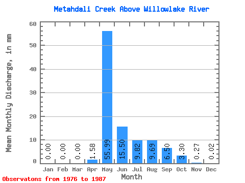
| Statistic | Jan | Feb | Mar | Apr | May | Jun | Jul | Aug | Sep | Oct | Nov | Dec | Annual |
|---|---|---|---|---|---|---|---|---|---|---|---|---|---|
| Mean | 0.00 | 0.00 | 0.00 | 1.58 | 55.98 | 15.50 | 9.82 | 9.68 | 6.49 | 3.30 | 0.27 | 0.01 | 101.63 |
| Standard Deviation | 0.00 | 0.00 | 0.00 | 2.02 | 35.77 | 16.14 | 10.14 | 15.69 | 11.11 | 4.79 | 0.51 | 0.03 | 69.34 |
| Min | 0.00 | 0.00 | 0.00 | 0.00 | 11.83 | 2.12 | 0.64 | 0.09 | 0.10 | 0.05 | 0.00 | 0.00 | 30.65 |
| Max | 0.01 | 0.00 | 0.00 | 6.05 | 128.45 | 56.89 | 24.29 | 53.64 | 39.86 | 16.58 | 1.75 | 0.09 | 256.93 |
| Coefficient of Variation | 3.32 | 1.27 | 0.64 | 1.04 | 1.03 | 1.62 | 1.71 | 1.45 | 1.85 | 2.26 | 0.68 |
 Return to R-Arctic Net Home Page