|
|
|||||||||||||||||
| Point ID: 362 | Downloads | Plots | Site Data | Code: 05CA003 |
|
|
|||||||||||||||||
| Download | |
|---|---|
| Site Descriptor Information | Site Time Series Data |
| Link to all available data | |
| View: | Time Series | All |
| Units: | m3/s |
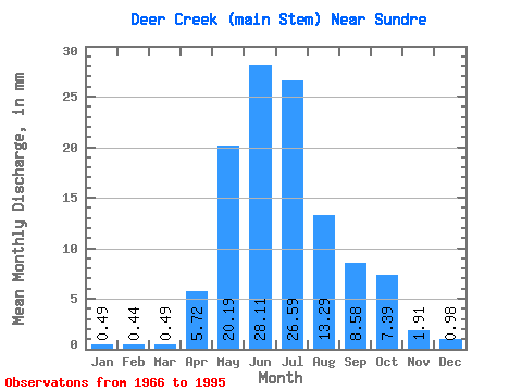
| Statistic | Jan | Feb | Mar | Apr | May | Jun | Jul | Aug | Sep | Oct | Nov | Dec | Annual |
|---|---|---|---|---|---|---|---|---|---|---|---|---|---|
| Mean | 0.70 | 0.39 | 0.59 | 5.82 | 19.97 | 28.01 | 26.68 | 13.46 | 8.50 | 7.17 | 2.04 | 0.98 | 73.00 |
| Standard Deviation | 0.56 | 0.45 | 0.50 | 4.35 | 14.28 | 22.79 | 26.91 | 10.56 | 6.45 | 9.09 | 0.98 | 0.82 | 34.42 |
| Min | 0.00 | 0.00 | 0.00 | 0.00 | 1.97 | 1.43 | 0.49 | 1.48 | 1.43 | 1.48 | 0.95 | 0.00 | 35.78 |
| Max | 1.48 | 1.35 | 1.48 | 17.15 | 48.24 | 99.11 | 103.38 | 44.80 | 27.16 | 51.69 | 3.81 | 2.46 | 119.90 |
| Coefficient of Variation | 0.79 | 1.13 | 0.84 | 0.75 | 0.71 | 0.81 | 1.01 | 0.79 | 0.76 | 1.27 | 0.48 | 0.84 | 0.47 |
 Return to R-Arctic Net Home Page