|
|
|||||||||||||||||
| Point ID: 3614 | Downloads | Plots | Site Data | Code: 10FB001 |
|
|
|||||||||||||||||
| Download | |
|---|---|
| Site Descriptor Information | Site Time Series Data |
| Link to all available data | |
| View: | Time Series | All |
| Units: | m3/s |
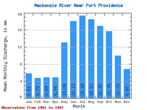
| Statistic | Jan | Feb | Mar | Apr | May | Jun | Jul | Aug | Sep | Oct | Nov | Dec | Annual |
|---|---|---|---|---|---|---|---|---|---|---|---|---|---|
| Mean | 5.81 | 4.83 | 4.89 | 4.94 | 13.08 | 18.14 | 19.38 | 18.51 | 16.92 | 15.74 | 10.03 | 6.82 | 137.47 |
| Standard Deviation | 1.50 | 1.27 | 1.25 | 1.14 | 2.21 | 2.33 | 3.17 | 3.59 | 3.38 | 3.33 | 2.93 | 1.37 | 23.15 |
| Min | 3.50 | 2.96 | 3.47 | 3.23 | 10.66 | 13.09 | 12.43 | 11.48 | 10.55 | 10.44 | 5.98 | 4.10 | 112.80 |
| Max | 7.76 | 6.65 | 7.00 | 6.59 | 16.89 | 22.09 | 23.53 | 24.16 | 22.27 | 21.64 | 15.84 | 8.99 | 174.57 |
| Coefficient of Variation | 0.26 | 0.26 | 0.25 | 0.23 | 0.17 | 0.13 | 0.16 | 0.19 | 0.20 | 0.21 | 0.29 | 0.20 | 0.17 |
 Return to R-Arctic Net Home Page