|
|
|||||||||||||||||
| Point ID: 3609 | Downloads | Plots | Site Data | Code: 10ED006 |
|
|
|||||||||||||||||
| Download | |
|---|---|
| Site Descriptor Information | Site Time Series Data |
| Link to all available data | |
| View: | Time Series | All |
| Units: | m3/s |
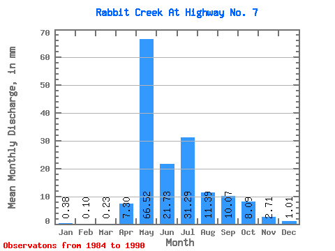
| Statistic | Jan | Feb | Mar | Apr | May | Jun | Jul | Aug | Sep | Oct | Nov | Dec | Annual |
|---|---|---|---|---|---|---|---|---|---|---|---|---|---|
| Mean | 0.39 | 0.10 | 0.22 | 7.29 | 66.51 | 21.74 | 31.28 | 11.40 | 10.07 | 8.10 | 2.72 | 1.02 | 159.32 |
| Standard Deviation | 0.30 | 0.12 | 0.24 | 6.08 | 37.09 | 21.34 | 38.70 | 11.21 | 13.08 | 9.72 | 1.37 | 0.93 | 95.79 |
| Min | 0.09 | 0.00 | 0.00 | 0.50 | 2.75 | 1.31 | 0.90 | 0.49 | 0.36 | 0.55 | 0.50 | 0.29 | 60.44 |
| Max | 0.81 | 0.34 | 0.61 | 15.32 | 116.72 | 60.12 | 107.19 | 32.94 | 37.47 | 28.89 | 4.70 | 2.80 | 320.77 |
| Coefficient of Variation | 0.77 | 1.13 | 1.07 | 0.83 | 0.56 | 0.98 | 1.24 | 0.98 | 1.30 | 1.20 | 0.50 | 0.91 | 0.60 |
 Return to R-Arctic Net Home Page