|
|
|||||||||||||||||
| Point ID: 3607 | Downloads | Plots | Site Data | Code: 10ED004 |
|
|
|||||||||||||||||
| Download | |
|---|---|
| Site Descriptor Information | Site Time Series Data |
| Link to all available data | |
| View: | Time Series | All |
| Units: | m3/s |
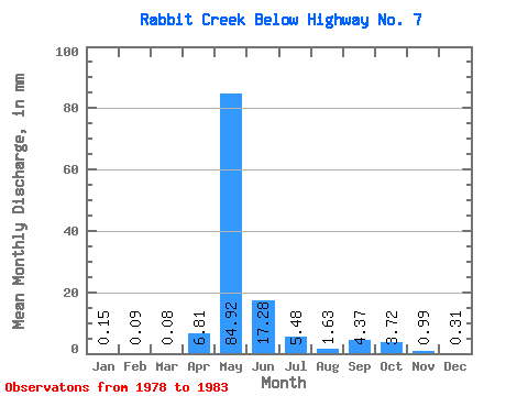
| Statistic | Jan | Feb | Mar | Apr | May | Jun | Jul | Aug | Sep | Oct | Nov | Dec | Annual |
|---|---|---|---|---|---|---|---|---|---|---|---|---|---|
| Mean | 0.14 | 0.09 | 0.07 | 6.81 | 84.91 | 17.27 | 5.47 | 1.64 | 4.36 | 3.72 | 0.99 | 0.31 | 124.48 |
| Standard Deviation | 0.09 | 0.06 | 0.07 | 4.58 | 83.19 | 15.31 | 7.15 | 1.95 | 5.65 | 3.49 | 0.98 | 0.26 | 74.78 |
| Min | 0.03 | 0.02 | 0.03 | 0.81 | 2.40 | 0.30 | 0.23 | 0.15 | 0.20 | 0.43 | 0.25 | 0.05 | 62.07 |
| Max | 0.26 | 0.19 | 0.20 | 12.64 | 237.45 | 36.29 | 18.16 | 5.33 | 13.70 | 10.36 | 2.86 | 0.79 | 249.05 |
| Coefficient of Variation | 0.59 | 0.72 | 1.02 | 0.67 | 0.98 | 0.89 | 1.31 | 1.19 | 1.29 | 0.94 | 1.00 | 0.83 | 0.60 |
 Return to R-Arctic Net Home Page