|
|
|||||||||||||||||
| Point ID: 3600 | Downloads | Plots | Site Data | Code: 10EB002 |
|
|
|||||||||||||||||
| Download | |
|---|---|
| Site Descriptor Information | Site Time Series Data |
| Link to all available data | |
| View: | Time Series | All |
| Units: | m3/s |
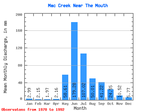
| Statistic | Jan | Feb | Mar | Apr | May | Jun | Jul | Aug | Sep | Oct | Nov | Dec | Annual |
|---|---|---|---|---|---|---|---|---|---|---|---|---|---|
| Mean | 2.98 | 2.17 | 1.97 | 2.16 | 58.60 | 179.28 | 107.01 | 50.00 | 41.22 | 24.55 | 10.53 | 5.77 | 485.32 |
| Standard Deviation | 1.14 | 1.08 | 0.84 | 0.95 | 32.31 | 41.71 | 44.14 | 14.54 | 19.81 | 11.53 | 5.25 | 2.55 | 73.94 |
| Min | 1.34 | 1.03 | 0.77 | 0.34 | 21.70 | 121.20 | 44.63 | 22.57 | 15.60 | 10.04 | 4.42 | 2.67 | 341.79 |
| Max | 5.08 | 4.52 | 3.74 | 3.60 | 126.46 | 256.80 | 203.33 | 80.46 | 80.76 | 48.10 | 23.28 | 11.72 | 611.41 |
| Coefficient of Variation | 0.38 | 0.50 | 0.43 | 0.44 | 0.55 | 0.23 | 0.41 | 0.29 | 0.48 | 0.47 | 0.50 | 0.44 | 0.15 |
 Return to R-Arctic Net Home Page