|
|
|||||||||||||||||
| Point ID: 360 | Downloads | Plots | Site Data | Code: 05CA001 |
|
|
|||||||||||||||||
| Download | |
|---|---|
| Site Descriptor Information | Site Time Series Data |
| Link to all available data | |
| View: | Time Series | All |
| Units: | m3/s |
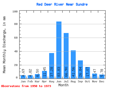
| Statistic | Jan | Feb | Mar | Apr | May | Jun | Jul | Aug | Sep | Oct | Nov | Dec | Annual |
|---|---|---|---|---|---|---|---|---|---|---|---|---|---|
| Mean | 4.69 | 4.86 | 6.50 | 11.45 | 37.27 | 83.83 | 66.89 | 41.55 | 26.84 | 17.07 | 7.47 | 5.78 | 252.41 |
| Standard Deviation | 0.21 | 0.28 | 2.01 | 5.36 | 12.36 | 26.06 | 22.37 | 15.42 | 12.56 | 6.61 | 1.89 | 2.16 | 3.79 |
| Min | 4.45 | 4.59 | 4.55 | 5.63 | 22.16 | 46.43 | 30.44 | 26.89 | 14.57 | 9.64 | 5.91 | 4.17 | 249.72 |
| Max | 4.82 | 5.15 | 11.83 | 25.30 | 67.65 | 141.57 | 115.08 | 99.91 | 59.02 | 37.10 | 9.58 | 8.23 | 255.09 |
| Coefficient of Variation | 0.04 | 0.06 | 0.31 | 0.47 | 0.33 | 0.31 | 0.33 | 0.37 | 0.47 | 0.39 | 0.25 | 0.37 | 0.01 |
 Return to R-Arctic Net Home Page