|
|
|||||||||||||||||
| Point ID: 3579 | Downloads | Plots | Site Data | Code: 07SA004 |
|
|
|||||||||||||||||
| Download | |
|---|---|
| Site Descriptor Information | Site Time Series Data |
| Link to all available data | |
| View: | Time Series | All |
| Units: | m3/s |
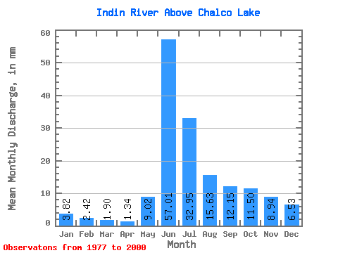
| Statistic | Jan | Feb | Mar | Apr | May | Jun | Jul | Aug | Sep | Oct | Nov | Dec | Annual |
|---|---|---|---|---|---|---|---|---|---|---|---|---|---|
| Mean | 3.82 | 2.45 | 1.90 | 1.34 | 9.02 | 57.01 | 32.94 | 15.62 | 12.15 | 11.50 | 8.94 | 6.53 | 164.17 |
| Standard Deviation | 1.92 | 1.11 | 0.77 | 0.50 | 8.37 | 27.61 | 11.31 | 7.38 | 14.45 | 12.05 | 5.96 | 3.63 | 60.44 |
| Min | 1.81 | 1.22 | 0.86 | 0.59 | 0.68 | 14.77 | 13.95 | 5.83 | 3.00 | 2.61 | 2.68 | 2.13 | 76.73 |
| Max | 9.25 | 5.20 | 3.72 | 2.49 | 28.72 | 100.78 | 58.32 | 34.88 | 76.57 | 63.43 | 27.45 | 15.40 | 307.21 |
| Coefficient of Variation | 0.50 | 0.45 | 0.41 | 0.37 | 0.93 | 0.48 | 0.34 | 0.47 | 1.19 | 1.05 | 0.67 | 0.56 | 0.37 |
 Return to R-Arctic Net Home Page